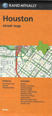
Skip to content
  • Texas Maps
    • Road Atlases
    • Wall Maps
    • Folded Maps
  • City Maps
    • Texas City Wall Maps
    • Street Guides
    • Folded Maps
  • Historical Maps
    • Texas
    • Topographic
    • County
    • War
  • Topographic Maps
    • Any Current US Topographic Map
    • Current Texas Topographic Maps
    • Historical Texas Topographic Maps
  • Classroom Maps
    • Earth Sciences
    • Educational
    • Historical
  • Outdoor Maps
    • Fishing Maps
    • Birding Maps
    • Current Topo Maps
  • Decorative Maps
    • Historical
    • Reference
  • Everything Else
    • Other State
      • Other State Historical Maps
    • USA
      • USA Historical Maps
      • USA Road Atlases
      • USA Wall Maps
    • Country Maps
    • World
      • World Wall Maps
    • Globes
    • Custom
      • Custom Design Maps
  • Log in
Cart
Texas Map Store | Have a question? | email: truenorth@gvtc.com
  • My Account
    • Login
    • Contact Us
  • View Cart
Texas Map Store Texas Map Store Texas Map Store Texas Map Store
Log in Search Cart
  • Texas Maps
    • Road Atlases
    • Wall Maps
    • Folded Maps
  • City Maps
    • Texas City Wall Maps
    • Street Guides
    • Folded Maps
  • Historical Maps
    • Texas
    • Topographic
    • County
    • War
  • Topographic Maps
    • Any Current US Topographic Map
    • Current Texas Topographic Maps
    • Historical Texas Topographic Maps
  • Classroom Maps
    • Earth Sciences
    • Educational
    • Historical
  • Outdoor Maps
    • Fishing Maps
    • Birding Maps
    • Current Topo Maps
  • Decorative Maps
    • Historical
    • Reference
  • Everything Else
    • Other State
      • Other State Historical Maps
    • USA
      • USA Historical Maps
      • USA Road Atlases
      • USA Wall Maps
    • Country Maps
    • World
      • World Wall Maps
    • Globes
    • Custom
      • Custom Design Maps
Home / Houston / Rand McNally. Rand McNally: Folded Maps

Houston

Houston

Click the product image or name for MORE INFO.

  • View all
  • City/ County Folded Maps
  • City/ County Street Guide
  • City/County Street Maps. City/County Street Maps: Baytown
  • City/County Street Maps. City/County Street Maps: Fort Bend County
  • City/County Street Maps. City/County Street Maps: Houston
  • City/County Street Maps. City/County Street Maps: Humble
  • City/County Street Maps. City/County Street Maps: Katy
  • City/County Street Maps. City/County Street Maps: La Porte
  • City/County Street Maps. City/County Street Maps: Missouri City
  • City/County Street Maps. City/County Street Maps: Pasadena
  • City/County Street Maps. City/County Street Maps: Richmond
  • City/County Street Maps. City/County Street Maps: Rosenberg
  • City/County Street Maps. City/County Street Maps: Sugar Land
  • Key Maps. Key Maps: Atlases
  • Rand McNally. Rand McNally: Folded Maps
  • TX City / County Maps. TX City / County Maps: Houston/Harris Co.
  • Universal Map. Universal Map: Folded Maps

Quick view
Houston by Rand McNally
$12.95
Quick view
Houston Regional by Rand McNally
$12.95
Houston by Rand McNally

Houston by Rand McNally

FOLD025

Regular price $12.95
-41 in stock

Rand McNally's 2014 folded map for Houston is a must-have for anyone traveling in and around this part of Texas, offering unbeatable accuracy and reliability at a great price. Features all Interstate, U.S., state, and county highways, along with clearly indicated parks, points of interest, airports, county boundaries, and streets. The easy-to-use legend and detailed index make for quick and easy location of destinations.
Communities covered: Bellaire, Bunker Hill Village, Hedwig Village, Hilshire Village, Hunters Creek Village, Meadows Place, Piney Point Village, Spring Valley, West University Place.
Insets include: Downtown Houston, Houston & Vicinity, and a Mileage & Driving Times Map.


Houston Regional by Rand McNally

Houston Regional by Rand McNally

FOLD033

Regular price $12.95
443 in stock

Rand McNally's major arterial folded map for Houston & Vicinity is a must-have for anyone traveling in and around this part of Texas, offering unbeatable accuracy and reliability at a great price. Features all Interstate, U.S., state, and county highways, along with clearly indicated parks, points of interest, airports, county boundaries, and streets. The easy-to-use legend and detailed index make for quick and easy location of destinations.
Communities covered: Baytown, Beaumont, Conroe, Galveston, La Porte, Lake Jackson, League City, Missouri City, Pasadena, Pearland, Sugar Land, and Texas City.
An inset of Downtown Houston is included as well as a mileage & driving times map.


Texas Map Store

Powered by Shopify


True North Publishing dba Texas Map Store has been publishing and selling maps for Texas since 1997. We continually strive to produce the most accurate and up-to-date maps available. We heartily welcome your suggestions, so please feel free to call, write or email any time.

More Stuff

  • Custom Maps
  • Purchase Orders
  • Tax Exempt Purchases
  • Contact Us
  • About Us
  • Shipping
  • Refunds and returns
  • Privacy Policy
  • Terms of Service

Categories

  • Texas Maps
  • City Maps
  • Historical Maps
  • Topographic Maps
  • Classroom Maps
  • Outdoor Maps
  • Decorative Maps
  • Everything Else

Join TMS Newsletter

Sign-up for Discounts, Coupons, New Product Arrivals and Recent News.

Texas Map Store

Powered by Shopify

  • american express
  • apple pay
  • diners club
  • discover
  • google pay
  • master
  • paypal
  • visa

All of our maps have a Free Shipping Option!