Skip to content
  • Texas Maps
    • Road Atlases
    • Wall Maps
    • Folded Maps
  • City Maps
    • Texas City Wall Maps
    • Street Guides
    • Folded Maps
  • Historical Maps
    • Texas
    • Topographic
    • County
    • War
  • Topographic Maps
    • Current
    • Historical
  • Classroom Maps
    • Earth Sciences
    • Educational
    • Historical
  • Outdoor Maps
    • Fishing Maps
    • Birding Maps
    • Current Topo Maps
  • Decorative Maps
    • Historical
    • Reference
  • Everything Else
    • Other State
      • Other State Historical Maps
    • USA
      • USA Historical Maps
      • USA Road Atlases
      • USA Wall Maps
    • World
      • World Wall Maps
    • Globes
    • Custom
      • Custom Design Maps
  • Log in
Cart
Texas Map Store | Have a question? | email: truenorth@gvtc.com
  • My Account
    • Login
    • Contact Us
  • View Cart
Texas Map Store Texas Map Store Texas Map Store Texas Map Store
Log in Search Cart
  • Texas Maps
    • Road Atlases
    • Wall Maps
    • Folded Maps
  • City Maps
    • Texas City Wall Maps
    • Street Guides
    • Folded Maps
  • Historical Maps
    • Texas
    • Topographic
    • County
    • War
  • Topographic Maps
    • Current
    • Historical
  • Classroom Maps
    • Earth Sciences
    • Educational
    • Historical
  • Outdoor Maps
    • Fishing Maps
    • Birding Maps
    • Current Topo Maps
  • Decorative Maps
    • Historical
    • Reference
  • Everything Else
    • Other State
      • Other State Historical Maps
    • USA
      • USA Historical Maps
      • USA Road Atlases
      • USA Wall Maps
    • World
      • World Wall Maps
    • Globes
    • Custom
      • Custom Design Maps
Home / Atascosa Co.

Atascosa Co.

Atascosa Co.

Click the product image or name for MORE INFO.

  • View all
  • City/ County Street Guide
  • Texmaps. Texmaps: Atlases
  • TX City / County Maps. TX City / County Maps: Atascosa Co.
  • TX City / County Maps. TX City / County Maps: Bee Co.
  • TX City / County Maps. TX City / County Maps: DeWitt Co.
  • TX City / County Maps. TX City / County Maps: Dimmit Co.
  • TX City / County Maps. TX City / County Maps: Duval Co.
  • TX City / County Maps. TX City / County Maps: Frio Co.
  • TX City / County Maps. TX City / County Maps: Gonzales Co.
  • TX City / County Maps. TX City / County Maps: Karnes Co.
  • TX City / County Maps. TX City / County Maps: La Salle Co.
  • TX City / County Maps. TX City / County Maps: Lavaca Co.
  • TX City / County Maps. TX City / County Maps: Live Oak Co.
  • TX City / County Maps. TX City / County Maps: Maverick Co.
  • TX City / County Maps. TX City / County Maps: McMullen Co.
  • TX City / County Maps. TX City / County Maps: San Antonio/Bexar Co.
  • TX City / County Maps. TX City / County Maps: Webb Co.
  • TX City / County Maps. TX City / County Maps: Wilson Co.
  • TX City / County Maps. TX City / County Maps: Zavala Co.

Quick view
Eagle Ford Shale Atlas by Texmaps, 2nd Ed. 2015
$34.95
Quick view
South of San Antonio Atlas by Texmaps
$24.95
Eagle Ford Shale Atlas by Texmaps, 2nd Ed. 2015

Eagle Ford Shale Atlas by Texmaps, 2nd Ed. 2015

MPBK065

Regular price $34.95
-1 in stock

This is the most comprehensive map of the Eagle Ford Shale area available! More than 150 pages of maps covering more than 20,000 square miles in the area from Eagle Pass to Halletsville. Fully indexed to help you quickly find landmarks and remote county roads.
Includes all or most of the following Counties: Atascosa, Bee, DeWitt, Dimmit, Duval, Frio, Gonzales, Karnes, La Salle, Lavaca, Live Oak, Maverick, McMullen, Webb, Wilson, Zavala. Includes GPS coordinates for rural areas.
Updated 2015
South of San Antonio Atlas by Texmaps

South of San Antonio Atlas by Texmaps

MPBK053

Regular price $24.95
-3 in stock

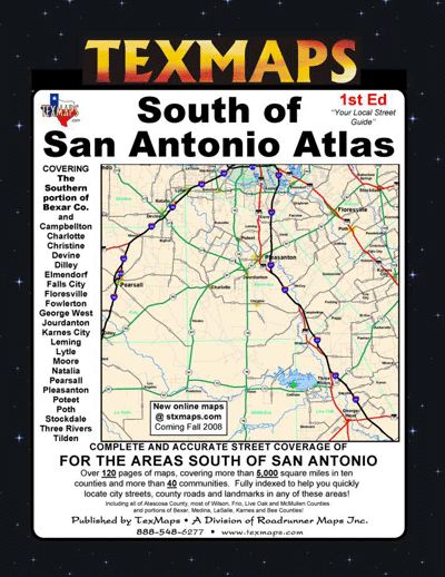
Detailed street maps of the area south of San Antonio. Covers all of Atascosa County, most of Wilson, Frio, Live Oak and McMullen Counties and portions of Bexar, Medina, LaSalle, Karnes and Bee. Includes the towns of Pleasanton, Pearsall, Floresville, Campbellton, Dilley, George West, Jourdanton, Karnes City, Poteet, Stockdale, Three Rivers and more. Over 120 pages of maps, covering over 5,000 sq miles in 10 counties and more than 40 communities.

Texas Map Store

Powered by Shopify


True North Publishing dba Texas Map Store has been publishing and selling maps for Texas since 1997. We continually strive to produce the most accurate and up-to-date maps available. We heartily welcome your suggestions, so please feel free to call, write or email any time.

More Stuff

  • Custom Maps
  • Tax Exempt Purchases
  • Contact Us
  • About Us
  • Shipping
  • Refunds and returns
  • Privacy Policy
  • Terms of Service

Categories

  • Texas Maps
  • City Maps
  • Historical Maps
  • Topographic Maps
  • Classroom Maps
  • Outdoor Maps
  • Decorative Maps
  • Everything Else

Join TMS Newsletter

Sign-up for Discounts, Coupons, New Product Arrivals and Recent News.

Texas Map Store

Powered by Shopify

  • american express
  • diners club
  • discover
  • jcb
  • master
  • paypal
  • visa

Everything Ships Free!

Welcome to the Texas Map Store

where every item has a free shipping option!