Skip to content
  • Texas Maps
    • Road Atlases
    • Wall Maps
    • Folded Maps
  • City Maps
    • Texas City Wall Maps
    • Street Guides
    • Folded Maps
  • Historical Maps
    • Texas
    • Topographic
    • County
    • War
  • Topographic Maps
    • Current
    • Historical
  • Classroom Maps
    • Earth Sciences
    • Educational
    • Historical
  • Outdoor Maps
    • Fishing Maps
    • Birding Maps
    • Current Topo Maps
  • Decorative Maps
    • Historical
    • Reference
  • Everything Else
    • Other State
      • Other State Historical Maps
    • USA
      • USA Historical Maps
      • USA Road Atlases
      • USA Wall Maps
    • World
      • World Wall Maps
    • Globes
    • Custom
      • Custom Design Maps
  • Log in
Cart
Texas Map Store | Have a question? | email: truenorth@gvtc.com
  • My Account
    • Login
    • Contact Us
  • View Cart
Texas Map Store Texas Map Store Texas Map Store Texas Map Store
Log in Search Cart
  • Texas Maps
    • Road Atlases
    • Wall Maps
    • Folded Maps
  • City Maps
    • Texas City Wall Maps
    • Street Guides
    • Folded Maps
  • Historical Maps
    • Texas
    • Topographic
    • County
    • War
  • Topographic Maps
    • Current
    • Historical
  • Classroom Maps
    • Earth Sciences
    • Educational
    • Historical
  • Outdoor Maps
    • Fishing Maps
    • Birding Maps
    • Current Topo Maps
  • Decorative Maps
    • Historical
    • Reference
  • Everything Else
    • Other State
      • Other State Historical Maps
    • USA
      • USA Historical Maps
      • USA Road Atlases
      • USA Wall Maps
    • World
      • World Wall Maps
    • Globes
    • Custom
      • Custom Design Maps
Home / Folded Maps

Folded Maps

Folded Maps


  • View all
  • City/ County Folded Maps
  • City/County Street Maps. City/County Street Maps: Addison
  • City/County Street Maps. City/County Street Maps: Arlington
  • City/County Street Maps. City/County Street Maps: Austin
  • City/County Street Maps. City/County Street Maps: Carrollton
  • City/County Street Maps. City/County Street Maps: Dallas
  • City/County Street Maps. City/County Street Maps: Farmers Branch
  • City/County Street Maps. City/County Street Maps: Fort Worth
  • City/County Street Maps. City/County Street Maps: Georgetown
  • City/County Street Maps. City/County Street Maps: Grand Prairie
  • City/County Street Maps. City/County Street Maps: Houston
  • City/County Street Maps. City/County Street Maps: Irving
  • City/County Street Maps. City/County Street Maps: Round Rock
  • City/County Street Maps. City/County Street Maps: San Antonio
  • Rand McNally. Rand McNally: Folded Maps
  • Texas Road Maps
  • Texas Road Maps. Texas Road Maps: Texas Folded Maps

Quick view
Texas by Rand McNally
$12.95
Quick view
Texas EasyToFold by Rand McNally
$12.95
Quick view
Austin/Georgetown/Round Rock by Rand McNally
$12.95
Quick view
San Antonio by Rand McNally
$12.95
Quick view
Dallas Fort Worth Regional Map
$12.95
Quick view
Dallas Street Map by Rand McNally
$12.95
Quick view
Houston by Rand McNally
$12.95
Quick view
Fort Worth Street Map by Rand McNally
$12.95
Quick view
Houston Regional by Rand McNally
$12.95
Texas by Rand McNally

Texas by Rand McNally

TEXAS04

Regular price $12.95
-65 in stock

Get bigger map type with the same great map detail, all for the same low price with Rand McNallys Easy to Read Texas Folded Map. Features all Interstate, U.S., state, and county highways, along with clearly indicated parks, points of interest, airports, county boundaries, and more. You'll also find great travel information about state parks, welcome center locations, points of interest, road condition hotline numbers, a state mileage chart, and more. Insets include: Abilene, Amarillo, Austin, Beaumont, Big Bend National Park, Bryan / College Station, Corpus Christi, Dallas/Fort Worth & Vicinity, El Paso, Galveston, Houston & Vicinity, Laredo, Lower Rio Grande Valley, Lubbock, Midland/Odessa, Port Arthur, San Antonio, Waco, and Wichita Falls.

Texas EasyToFold by Rand McNally

Texas EasyToFold by Rand McNally

TEXAS05

Regular price $12.95
-49 in stock

The durable and convenient Texas EasyToFold will take all the wear and tear your journey can dish out. The heavy-duty laminated design allows you to mark your route, make notes, then wipe the surface clean for further use. The full-color map features enhanced cartography with clearly indicated highways and interstates, points of interest, and national parks, along with a quick-reference legend and city index. It easily folds to display individual sections, eliminating the headache of refolding a paper map in the car.


Austin/Georgetown/Round Rock by Rand McNally

Austin/Georgetown/Round Rock by Rand McNally

FOLD008

Regular price $12.95
-12 in stock

Rand McNally's folded map for Austin (including Georgetown and Round Rock) is a must-have for anyone traveling in and around this part of Texas, offering unbeatable accuracy and reliability at a great price. Features all Interstate, U.S., state and county highways and streets, along with clearly indicated parks, points of interest, airports and county boundaries. The easy-to-use legend and detailed index make for quick and easy location of destinations.
Communities covered: Cedar Park, Pflugerville, Rollingwood, San Leanna, Sunset Valley, and West Lake Hills.
Insets include: Austin & Vicinity, Downtown Austin, and a Mileage & Driving Times Map.


San Antonio by Rand McNally

San Antonio by Rand McNally

FOLD050

Regular price $12.95
-11 in stock

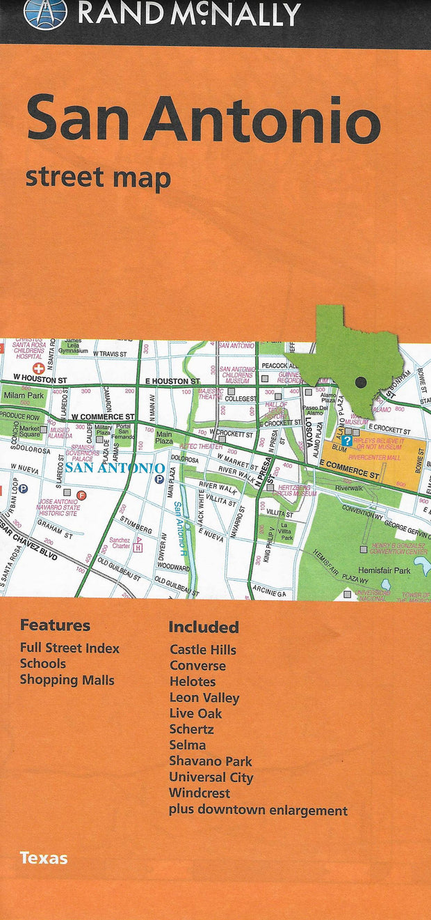
Rand McNally's folded map for San Antonio is a must-have for anyone traveling in and around this part of Texas, offering unbeatable accuracy and reliability at a great price. Features all Interstate, U.S., state, and county highways, along with clearly indicated parks, points of interest, airports, county boundaries, and streets.
Communities covered: Alamo Heights, Balcones Heights, Castle Hills, Converse, Helotes, Hill Country Village, Kirby, Leon Valley, Live Oak, Schertz, Selma, Shavano Park, Terrell Hills, Universal City, and Windcrest.
Insets include: Downtown San Antonio, San Antonio & Vicinity, and a Mileage & Driving Times Map.


Dallas Fort Worth Regional Map

Dallas Fort Worth Regional Map

FOLD014

Regular price $12.95
-21 in stock

Rand McNally's folded map for Dallas Fort Worth is a must-have for anyone traveling in and around this part of Texas, offering unbeatable accuracy and reliability at a great price. Our trusted cartography shows all Interstate, U.S., state, and county highways, along with clearly indicated parks, points of interest, airports, county boundaries, and streets. The easy-to-use legend and detailed index make for quick and easy location of destinations. You'll see why Rand McNally folded maps have been the trusted standard for years.

Communities included: Arlington, Cleburne, Corsicana, Denton, Garland, Greenville, Irving, McKinney and Plano.


Dallas Street Map by Rand McNally

Dallas Street Map by Rand McNally

FOLD015

Regular price $12.95
-15 in stock

Rand McNally's folded map for Dallas is a must-have for anyone traveling in and around this part of Texas, offering unbeatable accuracy and reliability at a great price. Our trusted cartography shows all Interstate, U.S., state, and county highways, along with clearly indicated parks, points of interest, airports, county boundaries, and streets. The easy-to-use legend and detailed index make for quick and easy location of destinations. You'll see why Rand McNally folded maps have been the trusted standard for years.

  • Regularly updated
  • Full-color maps
  • Clearly labeled Interstate, U.S., state, and county highways
  • Indications of parks, points of interest, airports, county boundaries, schools, shopping malls, downtown & vicinity maps
  • Easy-to-use legend
  • Detailed & full street index
  • Convenient folded size
  • Copyright 2017
Communities covered: Addison, Carrollton, Cockrell Hill, Farmers Branch, Grand Prairie, Highland Park, Irving, and University Park.

Insets include: Downtown Dallas

Houston by Rand McNally

Houston by Rand McNally

FOLD025

Regular price $12.95
-15 in stock

Rand McNally's 2014 folded map for Houston is a must-have for anyone traveling in and around this part of Texas, offering unbeatable accuracy and reliability at a great price. Features all Interstate, U.S., state, and county highways, along with clearly indicated parks, points of interest, airports, county boundaries, and streets. The easy-to-use legend and detailed index make for quick and easy location of destinations.
Communities covered: Bellaire, Bunker Hill Village, Hedwig Village, Hilshire Village, Hunters Creek Village, Meadows Place, Piney Point Village, Spring Valley, West University Place.
Insets include: Downtown Houston, Houston & Vicinity, and a Mileage & Driving Times Map.


Fort Worth Street Map by Rand McNally

Fort Worth Street Map by Rand McNally

FOLD022

Regular price $12.95
-21 in stock

Rand McNally's folded map for Fort Worth is a must-have for anyone traveling in and around this part of Texas, offering unbeatable accuracy and reliability at a great price. Our trusted cartography shows all Interstate, U.S., state, and county highways, along with clearly indicated parks, points of interest, airports, county boundaries, and streets. The easy-to-use legend and detailed index make for quick and easy location of destinations. You'll see why Rand McNally folded maps have been the trusted standard for years.

  • Regularly updated
  • Full-color maps
  • Clearly labeled Interstate, U.S., state, and county highways
  • Indications of parks, points of interest, airports, county boundaries, schools, shopping malls, downtown & vicinity maps
  • Easy-to-use legend
  • Detailed & full street index
  • Convenient folded size
  • Copyright 2019

COVERAGE AREA

Communities Included: Arlington,Bedford, Euless, Dalworthington Gardens, Edgecliff, Forest Hill, Haltom City, Hurst, Richland Hills, Rover Oaks, Sansom Park, Westover Hills, Westworth, White Settlement plus downtown enlargement.

PRODUCT DETAILS

Measures 9.5" x 4" and folds out to 40" x 28".


Houston Regional by Rand McNally

Houston Regional by Rand McNally

FOLD033

Regular price $12.95
468 in stock

Rand McNally's major arterial folded map for Houston & Vicinity is a must-have for anyone traveling in and around this part of Texas, offering unbeatable accuracy and reliability at a great price. Features all Interstate, U.S., state, and county highways, along with clearly indicated parks, points of interest, airports, county boundaries, and streets. The easy-to-use legend and detailed index make for quick and easy location of destinations.
Communities covered: Baytown, Beaumont, Conroe, Galveston, La Porte, Lake Jackson, League City, Missouri City, Pasadena, Pearland, Sugar Land, and Texas City.
An inset of Downtown Houston is included as well as a mileage & driving times map.


Texas Map Store

Powered by Shopify


True North Publishing dba Texas Map Store has been publishing and selling maps for Texas since 1997. We continually strive to produce the most accurate and up-to-date maps available. We heartily welcome your suggestions, so please feel free to call, write or email any time.

More Stuff

  • Custom Maps
  • Tax Exempt Purchases
  • Contact Us
  • About Us
  • Shipping
  • Refunds and returns
  • Privacy Policy
  • Terms of Service

Categories

  • Texas Maps
  • City Maps
  • Historical Maps
  • Topographic Maps
  • Classroom Maps
  • Outdoor Maps
  • Decorative Maps
  • Everything Else

Join TMS Newsletter

Sign-up for Discounts, Coupons, New Product Arrivals and Recent News.

Texas Map Store

Powered by Shopify

  • american express
  • diners club
  • discover
  • jcb
  • master
  • paypal
  • visa

Everything Ships Free!

Welcome to the Texas Map Store

where every item has a free shipping option!